Let me start by saying that the task in the title is obviously impossible in a single blog post - or even a few - and it would even be difficult to do it justice in a single book. My goal here is simply to outline the key events in the human settlement of the region, ignite some curiosity about the unanswered questions, and lay the foundation for future posts that will touch on various aspects of Southeast Asian prehistory.
For our purposes, ‘human’ means any member of the genus Homo - and that’s as good a place to begin as any. The search for human habitation in the region began with a Dutch physician named Eugène Dubois. Born in 1858, Dubois was fascinated by natural history and Darwin’s theory of evolution by natural selection in his youth. After graduating with a medical degree in 1884, in 1887 he joined the Dutch army, convinced that the ‘missing link’ between humans and apes would be found in the tropics - and in particular Southeast Asia. Posted to the Dutch East Indies, he spent the early part of his time there looking for human fossils in Sumatra, but turned his attention to Java in 1890. He soon hit the jackpot with the discovery of a fossil skullcap, femur and tooth at Trinil, in central Java, in 1891. Here, as he predicted, was the missing link, which he named Pithecanthropus erectus (later united with similar fossils found in China as Homo erectus).
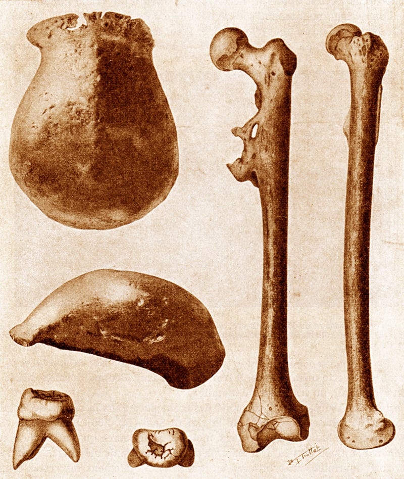
Java proved to be the paleoanthropological equivalent of a gold mine, and many more Homo erectus skeletal remains were discovered on the island in the subsequent four decades. Some of the oldest were found at Mojokerto and Sangiran by Ralph von Koenigswald and his Indonesian team in the 1930s. They have been dated to between 1.5 and 1.8 million years ago, which is incredibly early - roughly as old as those found in the 1990s at Dmanisi in Georgia, which are considered to be the earliest examples of Homo erectus outside of Africa.
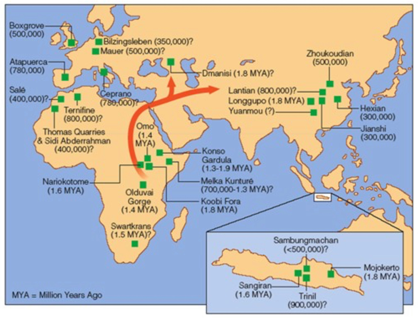
The implication of these early dates in Java, coupled with dates in Africa that are only slightly earlier, is that there was a migration out of Africa almost immediately after erectus appears in the fossil record. But how did they end up on a tropical island in Southeast Asia, in an environment seemingly far from the savannas they likely evolved on in eastern Africa? The answer lies in the complex geology of Southeast Asia, coupled with the rise and fall of sea levels during the Pleistocene ice ages.

The majority of Southeast Asia, from southern Thailand across to southern Vietnam and Cambodia, all of Malaysia, the southern Philippines, and Indonesia west of Sulawesi - including Java, Borneo and Sumatra - lies on the so-called Sunda Plate. It’s one of the most tectonically active regions in the world, part of the infamous ‘Ring of Fire’ that surrounds the Pacifc Ocean. The reason for the high level of tectonic activity around the Sunda Plate is that it’s being squeezed between the Australian Plate to the south, which is moving northward, and the massive Eurasian Plate to the north. As a result of this collision, the Australian Plate subducts - literally slides - underneath the Sunda Plate around the islands on Sumatra, Java, Bali and Lombok. As a result, these islands are subject to regular earthquakes as powerful as M9, as well as extensive volcanic activity as the edge of the crust is destabilized by the subduction. Indonesia’s largest and most active volcanoes sit in this zone, from Mount Toba in northern Sumatra (which erupted ~74,000 years ago - the largest volcanic eruption in the past several million years), to Krakatau between Sumatra and Java, Merapi in Central Java (the most active volcano in Indonesia) and eastward to Rinjani on Lombok and Tambora on the island of Sumbawa. All are very powerful, dangerous volcanoes whose eruptions have affected global climate periodically over the past millennium.
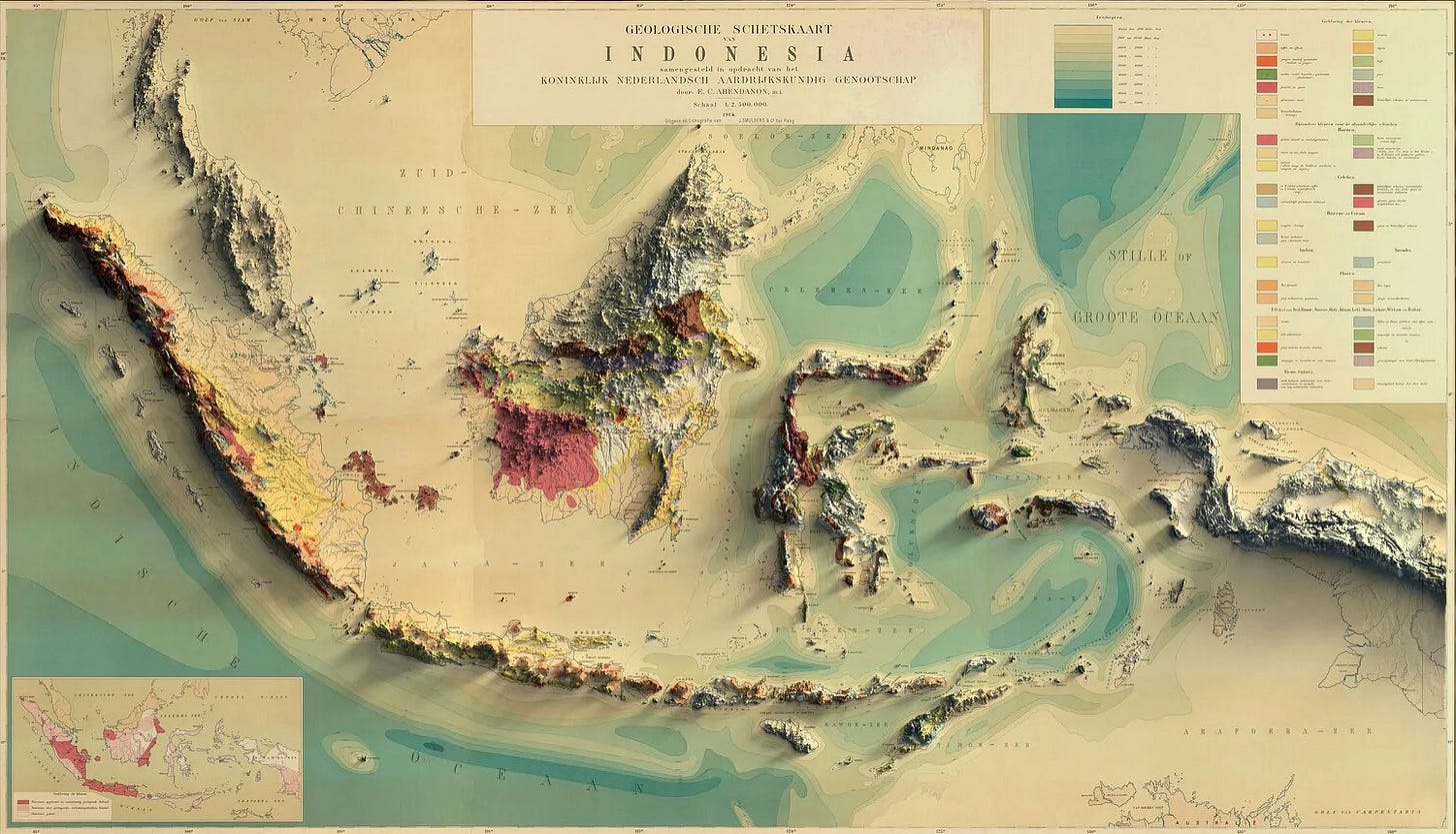
The outcome of all of this volcanic activity is twofold: first, a line of volcanic peaks as tall as 3800m (~12,500ft) along the southwestern edge of the Sunda Plate, and incredibly fertile soils on the islands where the volcanoes are located as a result of all of the volcanic ash that falls during eruptions. This ash is the reason, for instance, that densely-populated Java - the most crowded island in Indonesia, with ~155 million people packed onto an island approximately the size of Nepal - can sustain itself. Rich volcanic soils have allowed the cultivation of enough rice to feed the enormous population.
Apart from the enormous, belching volcanoes on the southern edge of the Sunda Plate, the other interesting geological feature is that the plate is being forced upward by the subduction of the Australian Plate. This means that the seas between the main islands of Sumatra, Java and Borneo, and Peninsular Malaysia in the northwest, are very shallow. The Java Sea has an average depth of 46m (150ft), for instance, and the Malacca Strait - the second-busiest shipping route in the world, separating Sumatra from Penisular Malaysia - is only around 25m (82ft) deep, on average.
The Pleistocene, which lasted from ~2.6 million to ~12,000 years ago, was marked by many extended ice ages, during which the moisture from the world’s oceans was drawn into expanding ice sheets in North America and Eurasia. This caused sea levels to drop by as much as 130m, far deeper than the shallow seas covering Sundaland. For extended periods during these ice ages, which could last for as much as 100,000 years, the Sunda Plate found itself above sea level - dry land that had previously been inundated under the shallow seas. A new subcontinent as large as Western Europe was created, uniting the large islands of Indonesia with the Asian mainland: Sundaland.
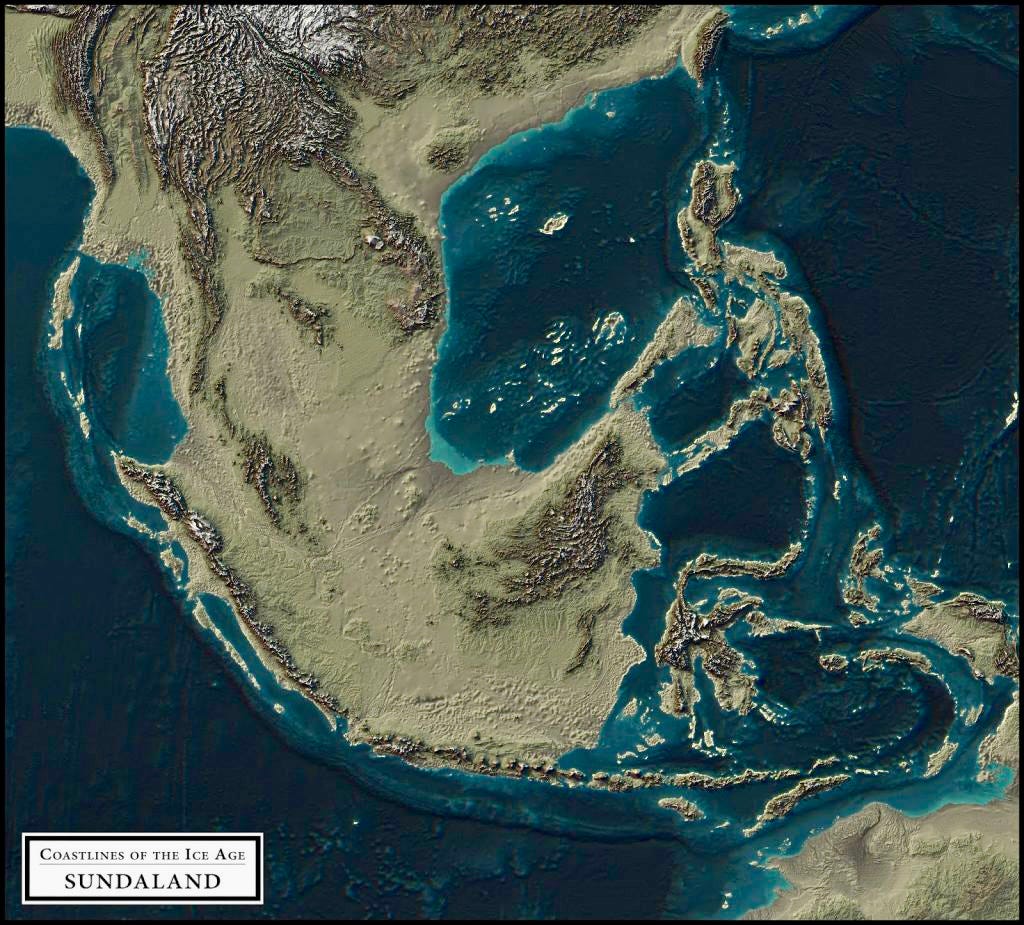
Sundaland would have emerged from the waves over thousands of years, as the ice sheets expanded during the Pleistocene cold phases. The first land exposed, along the margins of today’s islands, would have been virgin territory - coral and salty sand, with no terrestrial species. Gradually, though, through the copious rainfall of the tropics, mineral-rich ash falling from nearby volcanoes, and rivers carrying silt with organic material downstream from the highlands, the land would be colonized. What would eventually emerge, perhaps within a few hundred years of the seas receding, would be the beginnings of what would eventually become a vast plain between the former islands.
What would this plain have been like? Humid lowland rainforest, you’re probably thinking. In many places, yes - but much of the exposed land was a rich savanna straddling the Indian and Pacific Oceans. Why? Lower ocean temperatures during the ice ages reduced the amount of moisture in the air, so there was simply less rainfall overall (there are also thought to have been glaciers in the highlands of what is now Borneo, particularly near the summit of Mount Kinabalu).
In addition, the long line of fringing volcanoes on the southern edge of Sundaland would have created a rain shadow inland. Any incoming moisture would have been dumped as rain (and perhaps snow at higher altitudes) on the volcanic slopes, in the same way that oceanic moisture is cooled into rainfall on the slopes of Indonesia’s volcanoes today. By the time the atmospheric flow made it to the center of the continent, it would have been much drier, favoring a savanna environment over the lowland rainforests that prevail in much of the region today.
Today these savannas have largely disappeared, though there are remnants in a few locations, particularly at Baluran National Park in East Java. Here you can see large ungulates such as buffalo and deer grazing on grasslands dotted with acacia trees, stalked by leopards (in the Pleistocene there would have been tigers, rhinos and elephants as well), all in the shadow of Baluran volcano - very evocative of East Africa.
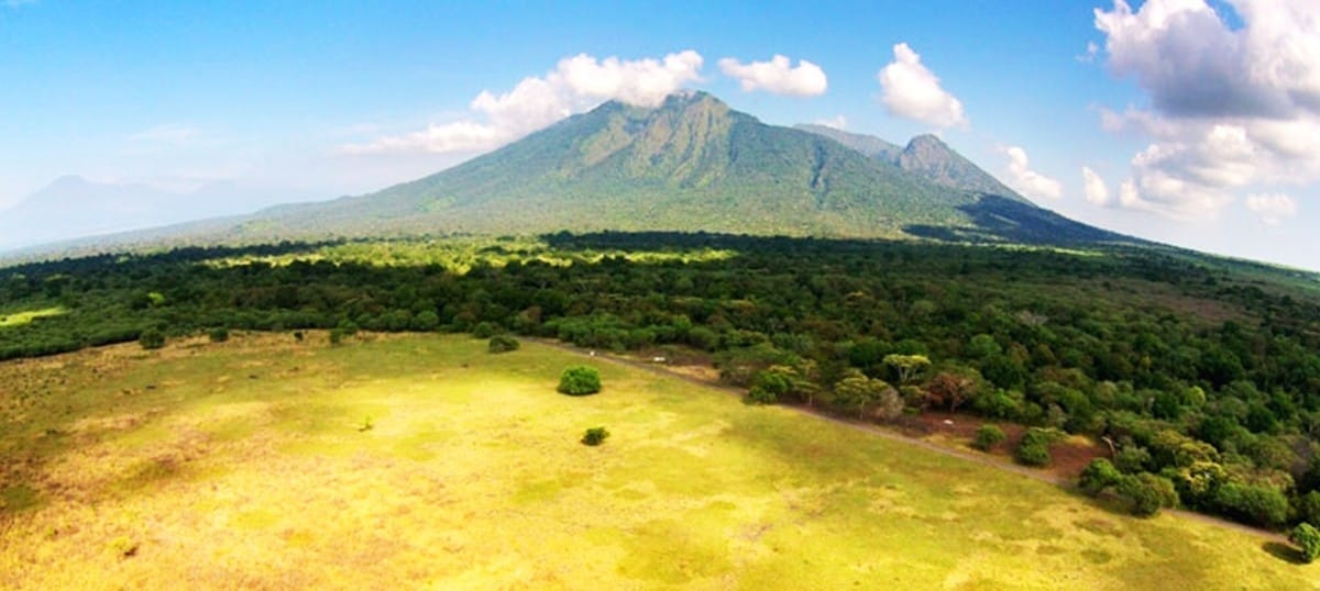
Baluran illustrates why early humans would have thrived in Southeast Asia for nearly two million years: until about 12,000 years ago Sundaland was a rich African-style savanna environment that would have felt like an evolutionary ‘home’ to these early humans. Rich game, copious water in the large river systems pouring onto the savanna from the surrounding highlands, punctuated by large lakes - a hominin paradise. In Part 2 we’ll delve further into exactly which hominins would have made their homes here in the Pleistocene, and the idiosyncratic evolutionary pathways they would have followed.



Wonderful explanation. Thanks!
Incredibly useful context for understanding the range of earlier humans!